Description
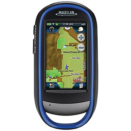
Rugged and waterproof (IPX-7 standards), the eXplorist 510 combines high sensitivity GPS reception with easy to read mapping and accurate navigation. Find your way using more than 30 navigational data fields. Create waypoints, record tracks, and route from point to point.
The integrated 3.2 mega-pixel camera, microphone, and speaker enables you to record geo-referenced images and voice notes. Relive and share your outdoor adventures.
The Magellan eXplorist 510 comes preloaded with the World Edition map allowing 2D or 3D viewing angles. It includes a complete road network in Australia, United States, Canada and Western Europe and major roads throughout the rest of the world. The eXplorist 510 has a micro SD card slot. This means you can access the following maps as an optional download via SD card – The GeoScience Australia 1:250k Raster Map, Summit Series Australia/New Zealand Topographic Map and the City Series Australia/New Zealand routable Tourer Map for the ultimate in outdoor navigation.
The eXplorist 510 navigation system combines the user friendliness of a touch screen with the reliability of two customisable hard buttons and the one touch favourites menu system giving you total control. Powered by two AA batteries (a pair of AA lithium batteries are supplied in the box with the unit), the eXplorist 510 will last up to 16 hours under normal conditions.
The eXplorist 510 offers paperless Geocaching. Download and view more than 20 unique characteristics of each cache, giving you seamless access to 21st Century treasure hunting.
The eXplorist 510. An easy to use touchscreen GPS receiver with core navigation at your fingertips.
Core Outdoor Navigation
Rugged and waterproof, with high sensitivity GPS reception and more than 30 navigational data fields. Create waypoints, record tracks, and route from point to point with backtrack feature for extra safety.
Experience Recording
Integrated 3.2 mega-pixel camera, microphone, and speaker enables you to record geo-referenced images and voice notes and relive or share your adventures.
Superior Maps with 3D Perspective View
The World Edition map allows for 2D or 3D viewing angles and covers the globe with details, roads and land use areas. You also have the option to download via SD the GeoScience Australia 1:250k Raster Map, the Summit Series Australia/New Zealand Topographic Map and the City Series Australia/New Zealand routable Tourer Map.
3.0
Combining the user friendliness of a touch screen with the reliability of two customisable hard buttons. Program the hard buttons to your two favourite or most used functions.
Paperless Geocaching
Download and view more than 20 unique characteristics of each cache and view, search, filter on the device.
16 Hours of Battery Life
Powered by two AA batteries, the eXplorist will last up to 16 hours under normal conditions. To help conserve power, use the suspend mode to turn off the device but maintain GPS tracking.
OneTouch Menu
Magellan’s award winning OneTouch(TM) favourites menu provides instant access to bookmarks of favourite places or actions. 12 customisable icons to create personalised searches, save unique locations, or assign quick access to your favourite screens. Giving you total control.
World Edition Premium Basemap Pre-loaded
The World Edition includes a complete road network in Australia, United States, Canada and Western Europe and major roads throughout the rest of the world that provides cartographic orientation in almost any location. This unique preloaded map also includes water features, urban and rural land use, and a realistic shaded relief background.
Area Calculation
A great tool to work out land area or property size. Set an active track, walk the perimeter of the track ensuring you return to your starting point and your eXplorist will calculate the area in square meters or square feet.


